Milwaukee's Freeway Past (UNDER CONSTRUCTION)
HISTORY
Milwaukee had a great plan for freeways in the 1950's and 1960's, but only about half of them came to fruition. This page
chronicles the evolution and devolution of the metro Milwaukee freeway system.
In the early 1950's traffic was choking Milwaukee. So in 1951 the City of Milwaukee hired consultants to
plan some freeways. The original 1952 plan called for 20.4 mile expressway system. By 1953, the first 2,200 foot
segment was already built. This segment was to become a part of the Stadium Freeway South, from National Avenue north along
43rd St.
In 1953 the city turned over its plans and some staff to Milwaukee County. This was partially due to neighbors who were not
cooperating, such as West Milwaukee. The county created the Expressway Commission to plan and buy right of way for the new freeways,
and the state Highway Commission was to build and maintain them. This was the case until the early 1960's, when the Southeast Wisconsin
Regional Planning Commission (SEWRPC) was formed to take over advisory planning for the seven southeast counties of Wisconsin.
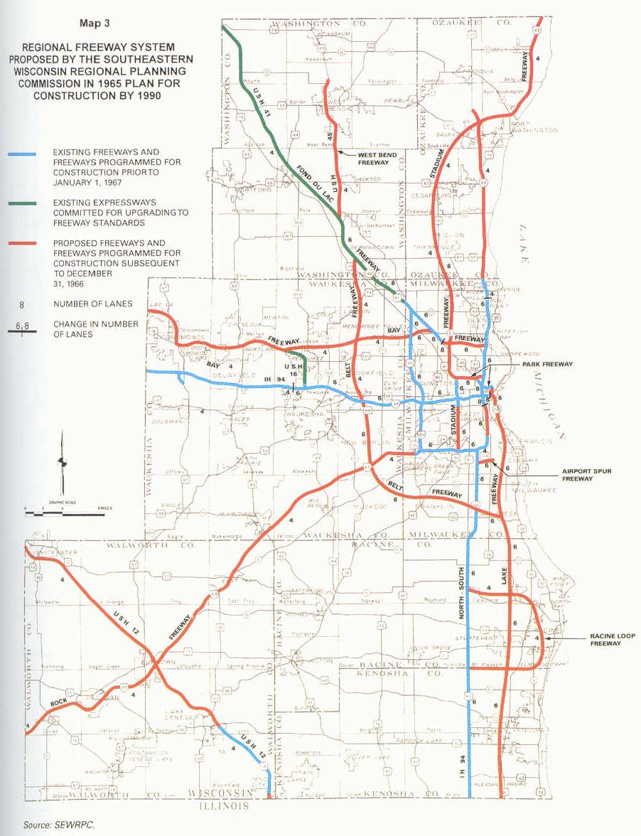
SEWRPC's 1965 plan was the high point of freeway plans.
A brief description of the 16 routes:
East-West Freeway: An east-west freeway to run from downtown Milwaukee at Lake Michigan westward to Madison.
Was built and is designated as
I-794 from the Lake Interchange to the Marquette Interchange, and as I-94 west of the Marquette Interchange.
North-South Freeway: A north-south freeway to skirt the western edge of downtown Milwaukee, going north toward Port Washington
and beyond, and south toward Chicago. Was built and is designated as I-43 north of the Marquette Interchange, as I-94 and I-43 south
of the Marquette Interchange to the Mitchell Interchange, and as I-94 south of the Mitchell Interchange.
Zoo Freeway: A north-south freeway to run along the western edge of Milwaukee County, from the Hale Interchange in Greenfield
north to the Granville Interchange in northwest Milwaukee. Was built and is designated as US 45 its entire length, and multiplexed with
I-894 from the Hale Interchange north to the Zoo Interchange.
Airport Freeway: An east-west freeway to run from the Mitchell Interchange west to the Hale Interchange, just south of
the City of Milwaukee. Was built and is designated as I-894 and I-43 its entire length.
Rock Freeway: A freeway to run southwest from the Hale Interchange in Greenfield towards Beloit and Janesville. (Rock County)
Was built and is designated as I-43.
Fond du Lac Freeway: A freeway to run northwest along Fond du Lac Avenue toward Washington County and beyond. Was almost
completely built, except for the very southeast end where it would connect with the Stadium Freeway and/or Park Freeway. Is designated
as STH-145 southeast of the Granville Interchange, and US 41/45 northwest of there.
Stadium Freeway: A north-south freeway to run north from the Airport Freeway in Greenfield, skirting the east edge of the
stadium, and then into Ozaukee County, where it would curve east to connect with the North-South Freeway. It was split into two portions,
the Stadium Freeway North, and the Stadium Freeway South. The East-West Freeway was the dividing point, at the Stadium Interchange.
Only a small portion was
built, from National Avenue just south of the stadium to North Avenue, which is about three miles. It is designated as US-41 north of the
Stadium Interchange, and as Miller Park Way and unsigned STH-341 south of there. The ROW was purchased and mostly cleared for the
leg south of National Avenue, but is is all now redeveloped. The interchange with the Airport Freeway was built completely, but in the
1980's or early 1990's the third level bridge from the Airport Freeway EB to Stadium Freeway NB was demolished during freeway rehab. The three
ramps remaining serve a park-n-ride lot just north of the Airport Freeway. It can be accessed via Loomis Road, and much of the defunct
interchange can be explored from there. (Credit Luke Pacholski)
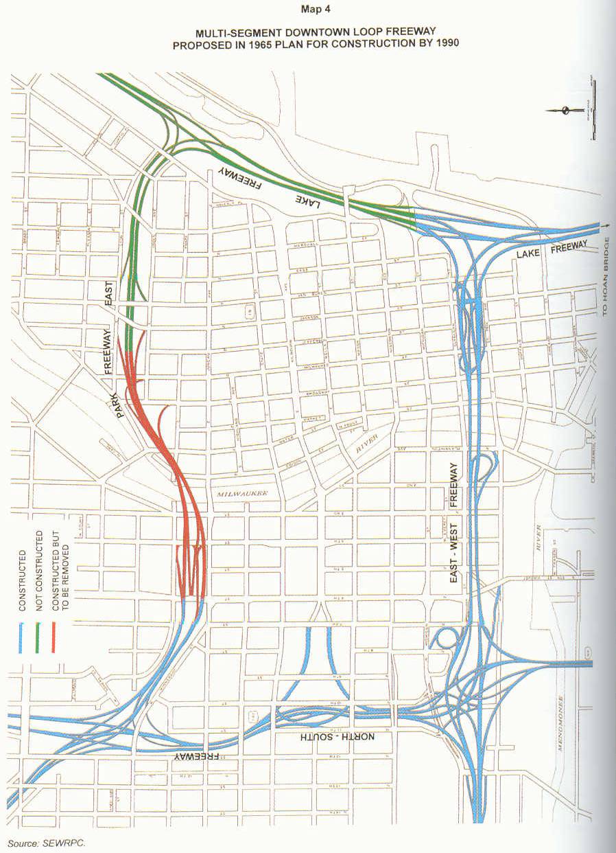
Park Freeway: An east-west freeway to skirt the northern edge of downtown Milwaukee, running from the lakeshore to the
Stadium Freeway. It was split into two portions, the
Park Freeway East, and the
Park Freeway West. The North-South Freeway was the
dividing point, at the Hillside Interchange. The Park Freeway East was 2/3 built, from the North-South Freeway to Jefferson St. The
ROW for the Park Freeway West was purchased and completely cleared, but construction never started. The built portion is designated
as STH-145.
Lake Freeway: A north-south freeway to run along Lake Michigan, parallel to the North-South Freeway, starting from the
northeast corner of downtown Milwaukee at the Park Freeway, and continuing south along the western edges of Racine and Kenosha, finally
connecting with some sort of Lake Shore Drive extension in Illinois.
Bay Freeway: An east-west freeway to run from the North-South Freeway near Whitefish Bay westward to Oconomowoc. Only the
portion between Pewaukee and Oconomowoc was built and is designated as STH-16.
US 16 Spur Freeway: A north-south freeway to connect the East-West Freeway and the Bay Freeway in Pewaukee. Was built and is
designated as STH-16.
Belt Freeway: A freeway in the western and southern suburbs. Was to start at the Fond du Lac Freeway in Germantown, go south
through Menomonee Falls, Brookfield, New Berlin, and Muskego, then turning east through Franklin and Oak Creek, where it would end at
the Lake Freeway. Was never built.
Airport Spur Freeway: An east-west freeway to connect Mitchell International Airport with the North-South Freeway. Was
built and is designated as STH-119, which is unsigned.
West Bend Freeway: A north-south freeway to branch off the Fond du Lac Freeway near Richfield, and then skirt the western
edge of West Bend. Was built and is designated as US-45.
Racine Loop Freeway: A freeway with both ends at the North-South Freeway. Was to loop through Racine. Was never built.
US 12 Freeway: A freeway to run from Genoa City on the Illinois border northwest towards Madison, skirting Lake Geneva and
Elkhorn. Was partially built, from Genoa City to Elkhorn. The rest of US 12 in Walworth county is still planned to happen when traffic
counts require it. (Whitewater bypass scheduled for completion in 2005)
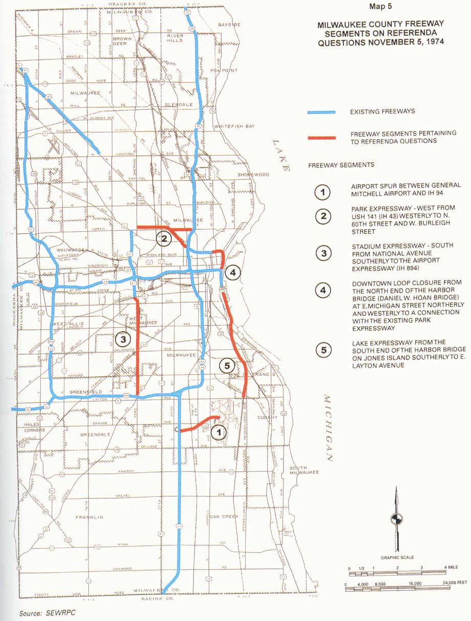
In the late 1960's the support for freeways began to erode. This led to SEWRPC reducing the freeways in its plan. The most
controvertial segment was the Park Freeway West. The ROW was bought and cleared by the early 1970's, but a judge ordered the letting
of construction contracts be halted, just days before they were to be let, on June 2, 1972. The battle raged for a few more years,
when a
non-binding referendum on November 5, 1974 asked Milwaukee County residents
about five freeway segments. Residents approved the construction by about 55%. But it was no use, as freeway opponents gained the upper
hand and eventually forced the abandonment of nearly all the proposed freeways in 1977.
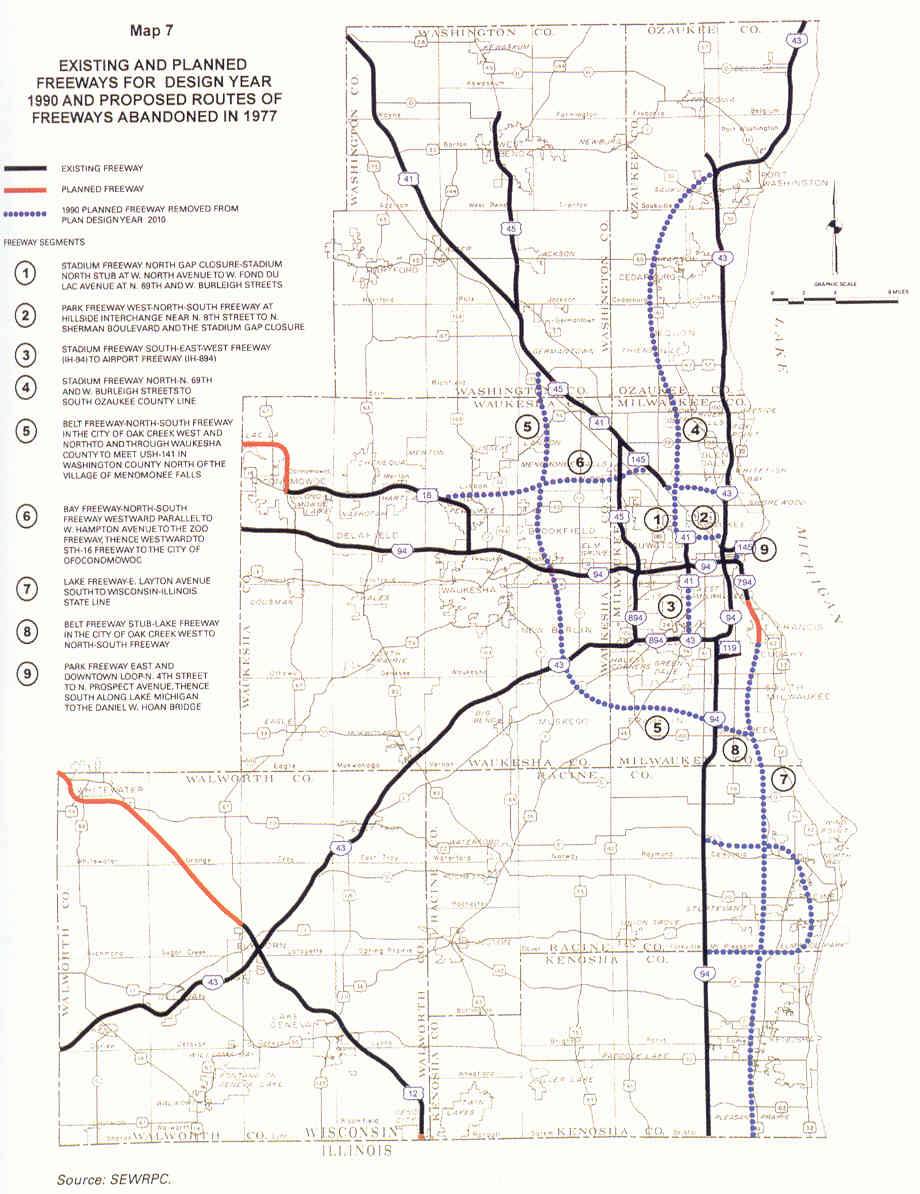
Of the three remaining freeway segments on the SEWRPC plan, only one has been built so far. That is the Lake Freeway, which was built
as a 4-lane parkway and is called the Lake Parkway. The Oconomowoc bypass will be finished in 2006, but it will be built as an
expressway. The US 12 freeway segment north of Elkhorn is the only segment that will be built as a freeway. Currently the
Whitewater bypass is being constructed, with completion being scheduled for 2005. As for the gap between Whitewater and Elkhorn,
plans call for a 'Super-2' to be built on new ROW with access control, when traffic counts on US 12 warrant. The second carriageway
would be built years later when the 'Super-2' is not adequate anymore. There is no timetable for this segment; sometime between 2015
and 2030 for the 'Super-2' seems probable.
Sources: Greater Milwaukee's Growing Pains, 1950-2000: An Insider's View, by Richard W. Cutler; WisDOT Web Site
REMNANTS OF THE CANCELLED FREEWAYS
Belt Freeway
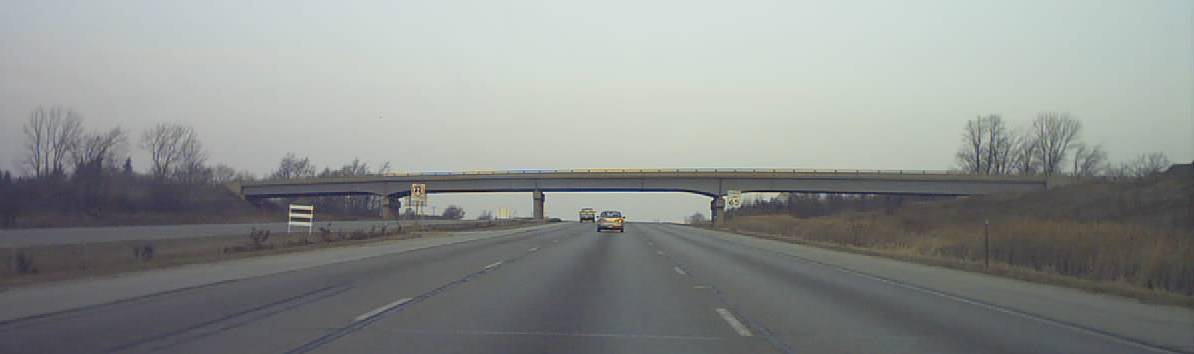
The Belt Freeway was planned to end in Germantown, just north of the STH 167 / CTH Y interchange, with a simple merge onto
US 41/45. The Mequon Road bridge over US 41/45, pictured above, is situated at the merge area. The Belt Freeway must have
still been on the books when the bridge was built, so it was built extra wide to allow for the two extra carriageways of the
merging Belt Freeway. This bridge is the only part of the Belt Freeway that midwestroads.com knows about that was built.